

Science
Why Mount Rainier Is The US Volcano Keeping Scientists Up At Night


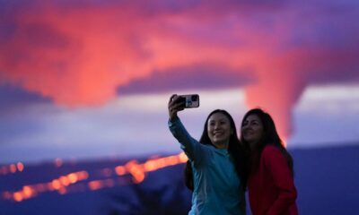
Mount Rainier, Washington’s snowcapped peak that stands 4.3 kilometers (2.7 miles) above sea level, has not had a significant volcanic eruption in the last 1,000 years. More than Hawaii’s exploding lava fields or Yellowstone’s vast supervolcano, Mount Rainier has many US volcanologists concerned.
“Mount Rainier keeps me awake at night because it poses a significant threat to the nearby villages. “Tacoma and South Seattle are built on 100-foot-thick (30.5-meter) ancient mudflows from Mount Rainier eruptions,” said Jess Phoenix, a volcanologist and ambassador for the Union of Concerned Scientists, on an episode of CNN’s “Violent Earth With Liv Schreiber.”


Volcano | CNN Image
Why Mount Rainier Is The US Volcano Keeping Scientists Up At Night
The sleeping giant’s deadly potential does not stem from flaming lava flows, which, in the case of an eruption, are unlikely to spread more than a few miles beyond the boundary of Mount Rainier National Park in the Pacific Northwest. According to the US Geological Survey, most volcanic ash will likely drift downwind to the east, away from populated centers.
Instead, many scientists are concerned about a lahar, a fast-moving slurry of water and volcanic rock formed when ice or snow is rapidly melted by an eruption. Lahars gather debris as they run down valleys and drainage channels.
According to Seth Moran, a research seismologist at USGS Cascades Volcano Observatory in Vancouver, Washington, Mount Rainier’s tall height and ice and snow cover make it resilient to eruptive activity. “Hot stuff … will melt the cold stuff and a lot of water will start coming down,” he explained.
“And there are tens, if not hundreds of thousands of people who live in areas that potentially could be impacted by a large lahar, and it could happen quite quickly.”
A lahar is a rapidly flowing debris flow.
The deadliest lahar in recent memory occurred in November 1985, when Colombia’s Nevado del Ruiz volcano erupted. Just a few hours after the eruption began, a flow of mud, rocks, lava, and freezing water surged over the village of Armero, killing over 23,000 people in minutes.
In an episode of CNN’s “Violent Earth,” Bradley Pitcher, a volcanologist and Columbia University lecturer in Earth and environmental sciences, described a hardened, concrete substance that can be difficult to escape.
Pitcher stated that Mount Rainier had approximately eight times the amount of glaciers and snow Nevado del Ruiz had when it erupted. “There’s the potential to have a much more catastrophic mudflow.”
According to the US Geological Survey’s 2018 threat assessment, Hawaii’s Kīlauea volcano is the most dangerous in the US, which is unsurprising given its proximity to the population and periodic eruptions. Mount St. Helens exploded violently in May 1980 and was voted second most dangerous, followed by Mount Rainier in third.
Lahars are most commonly associated with volcanic eruptions, but landslides and earthquakes can also create them. Moran said geologists have discovered evidence that at least 11 massive lahars from Mount Rainier have reached the surrounding area, known as the Puget Lowlands, over the last 6,000 years.
Scientists have not linked the most recent of these lahars, which occurred approximately 500 years ago, to any volcanic activity. According to analysts, the flow event could have been the result of a huge landslide on the mountain’s west face.
The loose, weak rock remains in that location, and Moran and other volcanologists are particularly concerned about the possibility of a similar, spontaneous landslide-induced lahar.


Volcano | CNN Image
Why Mount Rainier Is The US Volcano Keeping Scientists Up At Night
“We now know that the volcano can do it again. “And then we’re in this world where anything can happen at any time,” Moran explained.
“If it were the same size, it would be 10 minutes to the nearest places where people live and 60 minutes to the nearest significant settlements. “And those are very short time frames,” he added.
A 2022 study considered two worst-case scenarios. In the first scenario, a 260 million cubic meter, 4 meter deep (9.2 billion cubic feet, 13-foot deep) lahar would form on Mount Rainier’s west slope. According to Moran, the debris flow would be equivalent to 104,000 Olympic-size pools and could reach the heavily populated lowlands of Orting, Washington, roughly an hour after an eruption, moving at a rate of 13 feet (4 meters) per second.
According to the simulation, a second “pronounced hazard” area is the Nisqually River Valley, where a major lahar may displace enough water from Alder Lake to allow the 100-meter-tall (330-foot-tall) Alder Dam to spill over.
Mount Rainier’s neighbor, Mount St. Helens, farther south in the Cascade Range, erupted four decades ago, causing a disastrous lahar that did not reach any highly populated regions.
Venus Dergan and her then-boyfriend, Roald Reitan, were trapped in the Mount St. Helens lahar while on a camping vacation and are among the few persons known to have survived being swept up in a debris flow.
“I tried to cling on as we were swept downstream, but the tree bark was scraping. … During an interview for CNN’s “Violent Earth,” she recounted feeling it on her legs and arms.
“At one point, I went under the logs and dirt and accepted that this was the end. I was not going to get out of this, and I was going to die.


Volcano | CNN Image
Why Mount Rainier Is The US Volcano Keeping Scientists Up At Night
Following the explosion of Mount St. Helens, the US Geological Survey established a lahar detection system on Mount Rainier in 1998, which has been modified and expanded since 2017.
About 20 places on the volcano’s slopes and the two paths identified as most at risk of a lahar now have broadband seismometers that send real-time data and additional sensors such as trip wires, infrasound sensors, web cameras, and GPS receivers.
Moran explained that the device is designed to identify both a lahar if the volcano erupts in the future and a lahar caused by a landslide.
Because of the constraints of 1990s technology, the original system had limited bandwidth and power requirements, resulting in data transmission every two minutes.
In March, 45,000 kids from Puyallup, Sumner-Bonney Lake, Orting, White River, and Carbonado, Washington, took part in a lahar evacuation simulation. According to the USGS, this was the first time numerous school districts exercised on the same day, making it the world’s largest lahar drill.
Approximately 13,000 pupils walked up to 3.2 kilometers (2 miles) to specified areas outside of the defined lahar zone, while the remaining schools outside the lahar zone practiced sheltering in place.
Moran stated that the fail-safe components of the Lahar detection system are roughly 45 minutes away from the next significant community; thus, that was the time window within which communities had to work.
“Most of what happens at volcanoes is close by, and that’s why you try to keep people away because things happen fast, but lahars can travel a long way from the volcano and have a big impact.”
SOURCE – (CNN)


Canadian researchers are exploring novel techniques with plants to address major difficulties caused by bacterial infections, such as using antibacterial plants to control bacteria in poultry meat.
Antibiotics have been routinely used in poultry farming to prevent and treat bacterial infections. Antibiotic overuse has resulted in the rise of antibiotic-resistant microorganisms, endangering both animal and human health.
This has pushed scientists to investigate alternative methods of controlling bacterial infections in chickens, Agrinews Group reports.
Researchers in Canada are investigating the antibacterial properties of native plant extracts. Rumex and Potentilla are two distinct plants that have proven potential.
These plants are being studied for their effectiveness in battling bacterial infections such as Avian Pathogenic E. coli (APEC), a common cause of chicken sickness.
Rumex and Potentilla fight bacterial infections.
Dr. Sophie Kernéis-Golsteyn, a microbiologist at Lethbridge Polytechnic in Alberta, leads a 2.5-year Egg Farmers of Canada program.
Since 2016, her team has been testing native plants for antibacterial properties, collecting 150 samples. Rumex and Potentilla extracts are highly effective at protecting chickens from bacterial diseases.
These plants’ antibacterial properties are attributed to their ability to increase beneficial microbiota and stimulate the production of digestive enzymes. These botanical extracts reduce inflammation, strengthen the immune system, and improve overall productivity in poultry.
The use of antimicrobial flora in avian husbandry has many benefits. First, it reduces reliance on antibiotics, lowering the danger of antibiotic resistance.
Furthermore, it improves chicken health and well-being by boosting their immune response and digestive function. Finally, it aligns with client preferences for organic and sustainable agriculture practices.
While the potential benefits are significant, there are some drawbacks to consider. The efficiency of plant extracts may vary based on factors such as extraction technique, dosage, and the bacterial strains involved.
Furthermore, more research is required to fully understand the long-term impacts of using these plants in poultry production. The study of antimicrobial plants for bacterial control in chickens is a promising field of research in Canada.
Researchers are looking for effective and sustainable alternatives to antibiotics. One strategy is to leverage the natural properties of plants such as Rumex and Potentilla. This strategy reduces antibiotic resistance and improves the overall health and productivity of chicken farms.
Related News:
Mexico Wants US To Finance 4 Wind Power Plants


As summer approaches in Australia, residents are warned to look out for the funnel web spider, one of the country’s deadliest species.
In addition to advising the public to avoid funnel-web spiders during mating season, the Australian Reptile Park in New South Wales has even asked people to capture live funnel-web spiders so they can “milk” their venom.
Native to eastern Australia, the funnel web spider can kill humans in as little as fifteen minutes if they do not receive medical treatment for its poisonous bite.
There have been thirteen fatalities attributable to this species, but none since the development of antivenom in 1981. The Australian Reptile Park is appealing to the public for assistance capturing and donating spiders, as the serum relies on milking live spiders.
Hunting for the funnel net spider in residential areas is common practice after a particularly wet and warm season. Look for spiders in cool, dark places like pools, garden residue, heaps of dirty clothing, and outside shoes.
Australian Reptile Park spider keeper Emma Teni recently blogged about how they rely on spider donations more than ever, especially now that breeding season has arrived and the temperature is perfect.
“Male funnel-web spiders have short lifespans, and with approximately 150 spiders required to make just one vial of antivenom, we need the public’s help to ensure we have enough venom to meet demand.”
“If you spot an egg sac while collecting a spider, it’s important to safely collect that as well,” said Teni. “It can provide a robust supply of healthy young spiders to aid in our antivenom production.”
The spiders won’t be able to climb plastic or glass, but Teni suggests capturing funnel webs in a wide-mouthed jar with a cover. Then, you can lead the spiders into the container using a long spoon or something similar.
After that, fill the jar with moist soil, screw on the top, and bring it to the designated drop-off spot.
“We depend on the public for spider donations, and we want to make sure everyone stays safe during the collection process, especially with conditions being so favourable this year,” said Teni.
Related News:
Trudeau Orders Facebook to Block Presser Video from Australia
Science
A Spacecraft Is On Its Way To A Harmless Asteroid Slammed By NASA In A Previous Save-The-Earth Test


CAPE CANAVERAL, Florida – A spacecraft launched Monday to probe the site of a cosmic accident.
The European Space Agency’s Hera spacecraft launched on a two-year trip to the little, harmless asteroid slammed by NASA two years ago as a practice run for the day when a murderous space rock threatens Earth. It’s the second phase of a planetary defense experiment that could one day save the globe.
SpaceX’s Falcon rocket vanished with Hera into the late morning clouds. An hour later, cheering erupted in the control center in Germany as the spacecraft split from the rocket’s upper stage and returned home. “It’s an amazing day,” the space agency’s director general, Josef Aschbacher, said later.
The 2022 crash of NASA’s Dart spacecraft reduced Dimorphos’ orbit around its larger companion, indicating that if a harmful rock was heading our way, it might be pushed off course with adequate warning.
nasa
A Spacecraft Is On Its Way To A Harmless Asteroid Slammed By NASA In A Previous Save-The-Earth Test
Scientists are eager to analyze the aftermath of the impact up close to determine how effective Dart was and what improvements may be required to protect Earth in the future.
“The more detail we can glean the better as it may be important for planning a future deflection mission should one be needed,” University of Maryland astronomer Derek Richardson stated before launch.
Researchers want to know if Dart (short for Double Asteroid Redirection Test) created a crater or changed the 500-foot (150-meter) asteroid more dramatically. It seemed to be a flying saucer before Dart’s blow and may now resemble a kidney bean, according to Richardson, who participated in the Dart mission and is assisting Hera.
Dart’s wallop sent rubble and boulders hurtling off Dimorphos, adding to the impact’s momentum. For months, the debris track extended thousands of miles (almost 10,000 kilometers) into space.
According to flight director Ignacio Tanco, some rocks and debris may still be hovering about the asteroid, posing a threat to Hera.
A Spacecraft Is On Its Way To A Harmless Asteroid Slammed By NASA In A Previous Save-The-Earth Test
“We don’t really know very well the environment in which we are going to operate,” Tanco informed me. “But that’s the whole point of the mission is to go there and find out.”
European authorities refer to the $400 million (363 million euros) effort as a “crash scene investigation.”
“Hera is going back to the crime scene and getting all the scientific and technical information,” said project manager Ian Carnelli.
Carrying a dozen science instruments, the compact car-sized Hera must swing past Mars in 2025 for a gravitational boost before landing at Dimorphos by the end of 2026. It’s a moonlet of Didymos, the Greek word for twin, a five-times larger asteroid that spins quickly. At that point, the asteroids will be 120 million miles (195 million kilometers) from Earth.
Hera will attempt to enter orbit around the rocky duo, progressively reducing flyby distances from 18 miles (30 kilometers) to a half-mile (1 kilometer). The spacecraft will examine the moonlet for at least six months to determine its mass, shape, composition, and orbit around Didymos.
Before the crash, Dimorphos circled its larger partner from three-quarters of a mile (1,189 meters) away. Scientists believe the orbit has become tighter and more oval-shaped, and that the moonlet may be tumbling.
Two shoebox-sized Cubesats will launch from Hera for even closer drone-like examinations, with one employing radar to peek beneath the moonlet’s boulder-strewn surface. Scientists believe Dimorphos was produced from particles shed by Didymos. The radar measurements should assist in determining whether Didymos is the small moon’s parent.
A Spacecraft Is On Its Way To A Harmless Asteroid Slammed By NASA In A Previous Save-The-Earth Test
After their survey, the CubeSats will attempt to land on the moonlet. If the moonlet tumbles, the situation will become more complicated. Hera may potentially conclude its mission with a perilous touchdown but on the bigger Didymos.
Asteroids, which are remnants of the solar system’s origin 4.6 billion years ago, circle the sun principally between Mars and Jupiter in what is known as the main asteroid belt, where millions of them live. When they fall from the belt and land in our area, they become near-Earth objects.
NASA now has around 36,000 near-Earth objects, the majority of which are asteroids, although there are also some comets. More than 2,400 of them are deemed potentially dangerous to the Earth.
SOURCE | AP

Taylor Port Launches Sentinels Vintage Port

Man Creates Candy Cane Car to Spread Christmas Cheer

Amazon Strike Called By Teamsters Union 10,000 Walkout

Superman 2025 Trailer Drops With Great Fanfare

Amazon Encounters Numerous Strikes As Unions Aim At The Holiday Shopping Surge.

Miller Expects 4.9 Million Foreigners to Leave Canada Voluntarily

Nolinor Boeing 737 Crash Lands in Montreal

“Shocking Video” Vancouver Police Shoot Armed Suspect 10 Times

Increasing its Stake in OpenAI by $1.5 Billion is a Possibility for SoftBank.

Facebook Securities Fraud Case Dropped
“Shocking Video” Vancouver Police Shoot Armed Suspect 10 Times
Nolinor Boeing 737 Crash Lands in Montreal
Miller Expects 4.9 Million Foreigners to Leave Canada Voluntarily

Trudeau Orders Facebook to Block Australian Presser Video

Pro-Khalistanis Sikhs Attack Hindu Temple in Brampton


-
 Politics3 weeks ago
Miller Expects 4.9 Million Foreigners to Leave Canada Voluntarily
-
 News3 weeks ago
Nolinor Boeing 737 Crash Lands in Montreal
-
 News2 weeks ago
“Shocking Video” Vancouver Police Shoot Armed Suspect 10 Times
-
 Tech3 weeks ago
Increasing its Stake in OpenAI by $1.5 Billion is a Possibility for SoftBank.
-
 News4 weeks ago
Facebook Securities Fraud Case Dropped
-

 Health4 weeks ago
A Canadian Teenager’s Bird Flu Virus Has Mutations