
Fashion
Hurricane Hilary Grows Off Mexico And Could Reach California As A Very Rare Tropical Storm


MEXICO CITY, Mexico – Hurricane Hilary rapidly strengthened to Category 4 status off Mexico’s Pacific coast on Friday and might become the first tropical storm to hit Southern California in 84 years, causing major flooding, mudslides, and even tornadoes, according to forecasts.
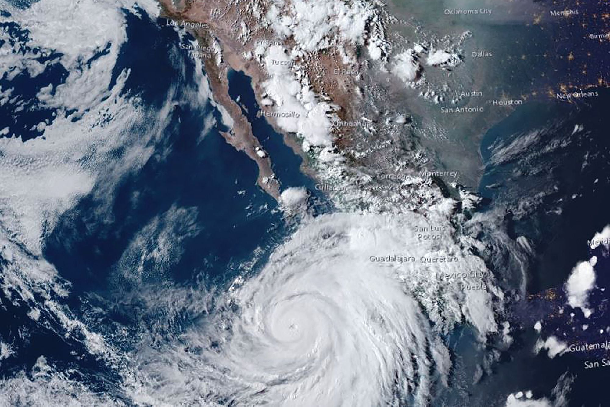
Early Friday, Hilary had sustained gusts near 145 mph (230 kph) and was forecast to grow slightly more before weakening. Nonetheless, it was predicted to be a hurricane as it approached Mexico’s Baja California peninsula on Saturday night and a tropical storm as it approached Southern California on Sunday.
The National Hurricane Centre issued its first tropical storm warning for much of Southern California on Friday, covering a large swath of the territory from the coast to the interior mountains and deserts.
According to the National Weather Service, no tropical storm has landed in Southern California since September 25, 1939. The alert warned of potential dangers to life and property, including severe flooding, mudslides, and tornadoes.
According to the Mexican government, a weakened Hilary could skim a sparsely inhabited area on the western side of the Baja peninsula early Sunday before making landfall between the cities of Playas de Rosarito and Ensenada.

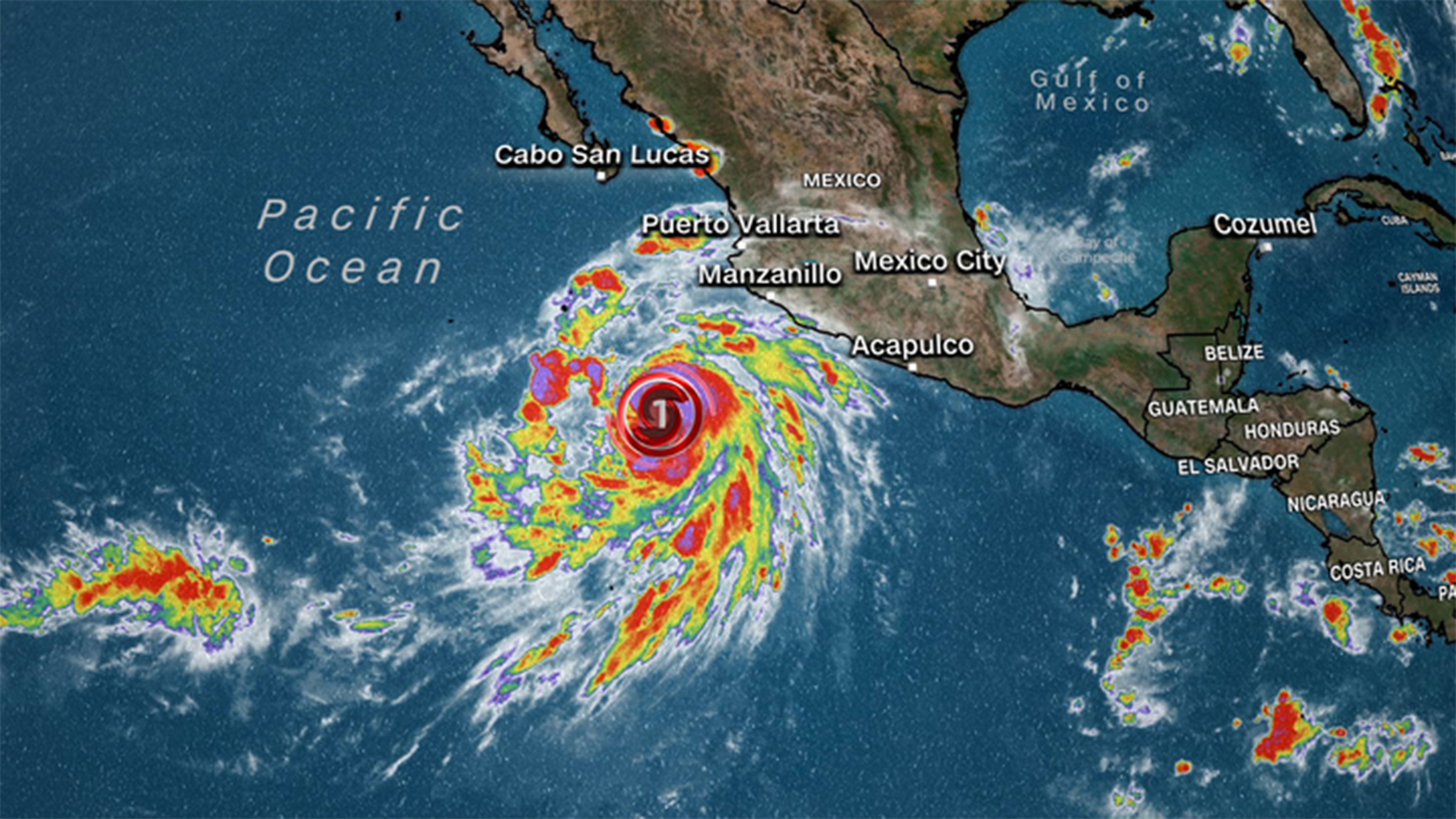
Hurricane Hilary rapidly strengthened to Category 4 status off Mexico’s Pacific coast on Friday and might become the first tropical storm to hit Southern California in 84 years.
The Mexican government issued hurricane warnings and watches for parts of the Baja California peninsula and a tropical storm watch for areas of mainland Mexico. 18,000 soldiers were placed on alert.
Hilary was centered approximately 360 miles (575 kilometers) south-southwest of Los Cabos, on the southern point of the Baja peninsula, early Friday. It traveled northwest at 10 mph (17 kph) and was predicted to continue northward.
Hilary was forecast to make landfall in southernmost California early Monday while still a tropical storm, though significant rain was expected to begin as early as Saturday, according to the National Weather Service’s San Diego office.
Officials predicted the storm could bring heavy rain to the Southwestern United States, dumping 3 to 6 inches in places and up to 10 inches in isolated regions in southern California and southern Nevada, causing flooding in big desert areas that aren’t used to getting much rain.
“The rain is the biggest potential threat,” said Colorado State University’s storm researcher Phil Klotzbach.
The region might experience once-in-a-century rains, and there’s a significant chance Nevada could beat its all-time rainfall record, according to Yale Climate Connections meteorologist Jeff Masters, a former government in-flight hurricane meteorologist.

Hurricane Hilary rapidly strengthened to Category 4 status off Mexico’s Pacific coast on Friday and might become the first tropical storm to hit Southern California in 84 years.
Cities across the region and on both sides of the border were preparing to set up stations for residents to get sandbags to protect their properties from floodwaters, while the National Park Service planned to close vulnerable areas of Joshua Tree National Park, east of Los Angeles, on Friday evening and suspend all backcountry camping.
SpaceX has postponed the launch of a satellite-carrying rocket from its central California base until at least Monday. The business stated that the conditions in the Pacific could make recovering the rocket booster challenging.
Storms rarely impact Southern California because prevailing winds often carry them northeastward into Mexico and other portions of the United States Southwest, according to Masters.
Because of a high-pressure heat dome that is likely to produce triple-digit heat indices in the Midwest, Hilary is expected to delay or not make that eastward shift. Because the heat dome is blocking the eastern turn, tropical moisture will likely travel into the Pacific Northwest and even Alberta, Canada, according to Masters.
He said that Hilary’s strength and breadth are amazing. In just 24 hours, the storm’s wind speed increased by 75 miles per hour, twice the legal threshold for rapid intensification. This is due to the storm passing over warm 86-degree (30 degrees Celsius) water, which fuels its heat engine.
However, that power will vanish once it encounters cooler 68-degree water around San Diego and heavy crosswinds.
SOURCE – (AP)